Les Planques

jdelettrez
User

Length
17 km

Max alt
993 m

Uphill gradient
383 m
Km-Effort
22 km

Min alt
855 m

Downhill gradient
385 m
Boucle
Yes
Creation date :
2018-06-26 16:30:50.35
Updated on :
2018-06-26 16:30:50.35
4h44
Difficulty : Medium

FREE GPS app for hiking
 SityTrail
IGN / Geographical institutes
SityTrail Plus
The world is yours!
About
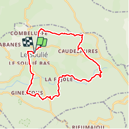
Trail Walking of 17 km to be discovered at Occitania, Hérault, Le Soulié. This trail is proposed by jdelettrez.
Description
Randonnée autour du Soulié
Positioning
Country:
France
Region :
Occitania
Department/Province :
Hérault
Municipality :
Le Soulié
Location:
Unknown
Start:(Dec)
Start:(UTM)
474945 ; 4822092 (31T) N.
Comments